

Habitat: Vegetation
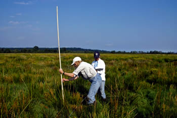
Vegetation survey, Phase II restoration site, Nisqually estuary.
The current and changing composition and condition of the vegetation community influence the spatial distribution and use by birds, mammals, and fish. Vegetation composition and condition indicate the extent and location of tidal marsh habitats. Vegetation monitoring will denote the presence and potential source populations for restored areas. Vegetation sampling, paired with aerial photography, habitat digitization, and elevation and bathymetric data will provide a project-scale temporal and spatial understanding of estuarine processes after restoration. In particular, coordinated sampling of vegetation with aerial photography can help with aerial photo interpretations of often complex habitats and land use characteristics.
There are a wide variety of options available when selecting vegetation monitoring methods (see References), though, for tidal marsh restorations, the primary objective remains change detection over time for the purpose of adaptive management. Additional considerations can be made to personalize vegetation monitoring based upon restoration goals and objectives. Additional considerations can be made to customize vegetation monitoring based upon restoration goals and objectives. For example, is it important to detect rare plants, quantify invasive species reduction, or measure suitable habitat for ground nesting birds, etc?
In Measuring & Monitoring Plant Populations (Elzinga et al. 1998), vegetation monitoring methods are divided into two main categories:
- Resource monitoring
- Focuses on plant resource itself
- Monitors aspect of that resource:
- Population size
- Average density
- Average cover
- Average frequency
- Habitat monitoring
- Describes how well an activity meets the objectives or management standards for the habitat. Examples include:
- Establishing plant height standards in a tidal marsh for nesting Virginia Rails and measuring how well a marsh meets those standards.
- Setting a threshold level of the percentage of habitat that may be disturbed by a particular activity, such as public access hiking trails.
Often, the same vegetation method can be used to answer both resource and habitat monitoring-related questions, though questions should be established prior to the start of a vegetation monitoring program. After restoration and monitoring objectives are established, methods can be selected based on site specific considerations and resources available.
We have created a vegetation monitoring protocol that incorporates both landscape-scale and ground-scale measurements. Our ground surveys use a combination of permanent photopoints, point intercepts, quadrats, photoplots and circular habitat and land use plots to best characterize community composition and structure across a gradient. Vegetative composition, height, and percent cover of plant species are collected in order to assess changes in vegetation through time. To quantify the physical characteristics that drive vegetation communities, we also measure pore-water salinity, soil texture and elevation. Standardized protocol for sampling and mapping marsh vegetation may be scaled up or down increasing the feasibility of collaborating with partner datasets for regional assessments.
Here we present a list of potential methods in relative order of lowest to highest complexity in terms of resources required (i.e. staff and equipment) and linkages to environmental conditions. Several methods link to slideshows and downloadable standard operating procedures and datasheets. Information on other methods can be found in the References section below.
- Photo-points
- Photoplots
- Habitat survey plots
- Mapping
- GPS habitat deliniation
- RTK GPS topographic and vegetation mapping
- Remote Sensing
- Aerial photograph habitat classification
- Survival surveys (vegetation plantings)
- Transects: percent cover, height
- Quadrats: percent cover, density, height
- Biomass
- Above ground
- Below ground
- Seasonal growth measurements (i.e. caliper, height and cover)
- Structure: leaf area index
- Soil testing (chemistry and texture)
- Productivity estimates based on carbon fixation
- Plant tissue nitrogen concentrations
References
Methods
Bonham, C.D. 1989. Measurements for Terrestrial Vegetation, John Wiley & Sons, Inc., New York, N.Y.
Erwin, K.L. 1990. Wetland evaluation for restoration and creation. Pages 429-458, In J.A. Kusler and M.E. Kentula (eds.) Wetland Creation and Restoration: The Status of the Science, Island Press, Washington, D.C.
Krebs, C. J. 1999. Ecological Methodology, 2nd edition. Benjamin/Cummings, New York, NY.
Washington State Department of Transportation (WSDOT). 2008. WSDOT Wetland Mitigation Site Monitoring Methods. Available online at: http://www.wsdot.wa.gov/NR/rdonlyres/C211AB59-D5A2-4AA2-8A76-3D9A77E01203/0/MethodsWhitePaper052004.pdf
(accessed 24 April 2012).
Zedler, J.B. 2001. Handbook for restoring tidal wetlands. CRC Press, New York.
Project Applications
Belleveau, L. J. In review. Determining how soil salinity and tidal inundation influence the distribution, species diversity and growth of salt marsh vegetation: implications for the restoration of the Nisqually Delta, Washington. M.S. Thesis, The Evergreen State College, Olympia, Washington.
Tanner, C.D., J.R. Cordell, J. Rubey, L.M. Tear. 2002. Restoration of freshwater intertidal habitat functions at Spencer Is., Everett, Washington. Res. Ecol. 10: 564-576.