Elevation: Terrestrial and Aerial LiDAR

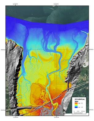
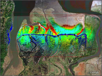
Light Detection And Ranging (LiDAR) is an optical remote sensing technology that can be used to measure bare earth surface elevations of tidal marsh habitats. LiDAR is a beneficial tool offering quick, broad scale collection of highly detailed terrain surface data. The elevation data collected by LiDAR serves as a dataset for examining geomorphic change and informing models. LiDAR is ideal for unvegetated areas above water (e.g. mudflats), but because LiDAR cannot penetrate water or vegetation it is unsuitable for measuring bare earth surface elevations in ponded areas or tidal marshes with dense vegetated cover. Additionally, some studies have shown error rates of ±15 cm reducing the utility of LiDAR in tidal marshes where centimeters of change in surface elevation affect habitat development and vertebrate response (Foxgrover 2005, Woo et al. 2009, Athearn et al. 2010).
Terrestrial or ground-based LiDAR is collected using a scanner mounted on a tripod and is useful in smaller sites (several acres to several hundred acres) or in areas where aerial LiDAR cannot penetrate (e.g. dense forest canopy, building shadows, cliff banks). Aerial LiDAR is collected using a scanner mounted to an airplane and allows for very large spatial coverage. Acquired LiDAR data should be ground-truthed for accuracy.
Benefits: Fast, accurate, lots of data, excellent spatial coverage, can be used to measure vegetation height; with right software can calculate volumetric differences between different time periods
Limitations: expensive, cannot penetrate vegetation or water to measure bare earth surface elevation
Methods: LiDAR requires highly specialized instrumentation and training. The following sources provide information on various methodologies used and available datasets:
USGS Center for LiDAR Information Coordination and Knowledge – site for facilitating data access, user coordination and education of LiDAR remote sensing for scientific needs.
Puget Sound LiDAR Consortium – source of public-domain high-resolution topography for the Pacific Northwest
References
Athearn, N., Takekawa, J.Y., Jaffe, B., Hattenbach, B.J., and A.C. Foxgrover. 2010. Mapping elevations of tidal wetland restoration sites in San Francisco Bay: comparing accuracy of aerial LiDAR with a singlebeam echosounder. Journal of Coastal Research 26(2): 312-319.
Foxgrover, A.C. and Jaffe, B.E., 2005. South San Francisco Bay 2004 Topographic LiDAR Survey: Data Overview and Preliminary Quality Assessment. U.S. Geological Survey Open-File Report OFR-2005-1284. 57p.
Hetherington, D.; German, S.; Utteridge, M.; Cannon, D.; Chisholm, N., and Tegzes, T., 2007. Accurately representing a complex estuarine environment using terrestrial lidar. RSPSoc Conference (Newcastle Upon Tyne, U.K., September 2007). 5p.
Lowe, T. 2003. Assessing the potential of LiDAR/bathymetry integration within the Thames estuary. FIG Working Week 2003 (Paris, France). Paper number PP20.2. 15p.
Populus, J.; Barreau, G.; Fazilleau, J.; Kerdreux, M., and L’Yavanc, J., 2001. Assessment of the LIDAR topographic technique over a coastal area. In: Proceedings of CoastGIS 2001 (Halifax, Canada). 12p.
Wang, C. and Philpot, W.D., 2007. Using airborne bathymetric lidar to detect bottom type variation in shallow waters. Remote Sensing of Environment106: 123–135.
Woo, I., R. Storesund, J.Y. Takekawa, R.J. Gardiner, and S. Ehret. 2009. Integrating Terrestrial LiDAR and Stereo Photogrammetry to Map the Tolay Lakebed in Northern San Francisco Bay. Pp 279-284 In Webb, R.M.T., and Semmens, D.J., editors. Planning for an uncertain future—Monitoring, integration, and adaptation. Proceedings of the Third Interagency Conference on Research in the Watersheds: U.S.Geological Survey Scientific Investigations Report 2009-5049.
Yang, X., 2005. Use of LIDAR elevation data to construct a highresolution digital terrain model for an estuarine marsh area. International Journal of Remote Sensing, 26(23), 5163–5166.

