Elevation: Bathymetric Mapping

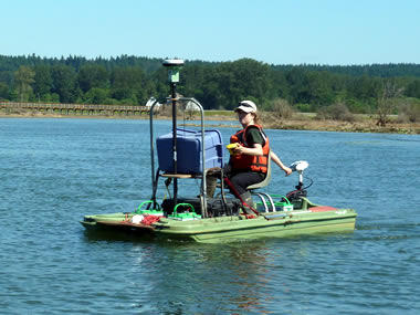
Underwater bathymetry compliments LiDAR and ground-based topographic mapping in inundated areas where LiDAR and RTK GPS data acquisition may not be feasible. Bathymetry uses sound navigation and ranging (sonar) technology to map seafloor terrain. Bathymetric data are a critical component for hydrodynamic models and provide a background layer or 3-D surface for draping thematic maps such as benthic and marine organism habitats or geologic data (NOAA 2007). Deep and shallow water bathymetry requires different boats and equipment for access and mapping.
Benefits: mobile, collects data quickly, good spatial coverage
Limitations: underwater application only, expensive
Methods: Bathymetric mapping requires specialized instrumentation and equipment that may vary due to monitoring objectives and local conditions (i.e. shallow-water versus deep-water). The following sources provide information on various methodologies used:
Athearn, N., Takekawa, J.Y., Jaffe, B., Hattenbach, B.J., and A.C. Foxgrover. 2010. Mapping elevations of tidal wetland restoration sites in San Francisco Bay: comparing accuracy of aerial LiDAR with a singlebeam echosounder. Journal of Coastal Research 26(2): 312-319.
Foxgrover, A.C., Finlayson, D.P., and Jaffe, B.E., 2011, 2010 Bathymetry and digital elevation model of Coyote Creek and Alviso Slough, south San Francisco Bay, California: U.S. Geological Survey Open-File Report 2011–1315, 20 p. and datasets, available at: http://pubs.usgs.gov/of/2011/1315/.
Lowe, T. 2003. Assessing the potential of LiDAR/bathymetry integration within the Thames estuary. FIG Working Week 2003 (Paris, France). Paper number PP20.2, 15p.
Takekawa, J.Y., I. Woo, N. D. Athern, S. Demers, R. J. Gardiner, W. M. Perry, N. K. Ganju, G. G. Shellenbarger, and D. H. Schoellammer. 2010. Measuring sediment accretion in early tidal marsh restoration. Wetlands Ecology and Management 18(3): 297-305 doi: 10.1007/s 11273-009-9170-6.
